A python implementation of the ITU-R P. Recommendations to compute atmospheric attenuation in slant and horizontal paths.
The propagation loss on an Earth-space path and a horizontal-path, relative to the free-space loss, is the sum of different contributions, namely: attenuation by atmospheric gases; attenuation by rain, other precipitation and clouds; scintillation and multipath effects; attenuation by sand and dust storms. Each of these contributions has its own characteristics as a function of frequency, geographic location and elevation angle. ITU-Rpy allows for fast, vectorial computation of the different contributions to the atmospheric attenuation.
The documentation can be found at ITU-Rpy documentation in Read the docs.
Examples of use cases can be found in the examples folder.
ITU-Rpy has the followind dependencies: numpy, scipy, pyproj, and astropy. Installation of cartopy and matplotlib is recommended to display results in a map.
Using pip, you can install all of them by running:
pip install iturMore information about the installation process can be found on the documentation.
The following ITU-R Recommendations are implemented in ITU-Rpy
- ITU-R P.453-13: The radio refractive index: its formula and refractivity data
- ITU-R P.530-17: Propagation data and prediction methods required for the design of terrestrial line-of-sight systems
- ITU-R P.618-13: Propagation data and prediction methods required for the design of Earth-space telecommunication systems
- ITU-R P.676-12: Attenuation by atmospheric gases
- ITU-R P.835-6: Reference Standard Atmospheres
- ITU-R P.836-6: Water vapour: surface density and total columnar content
- ITU-R P.837-7: Characteristics of precipitation for propagation modelling
- ITU-R P.838-3: Specific attenuation model for rain for use in prediction methods
- ITU-R P.839-4: Rain height model for prediction methods.
- ITU-R P.840-8: Attenuation due to clouds and fog
- ITU-R P.1144-10: Interpolation methods for the geophysical properties used to compute propagation effects
- ITU-R P.1510-1: Mean surface temperature
- ITU-R P.1511-2: Topography for Earth-to-space propagation modelling
- ITU-R P.1623-1: Prediction method of fade dynamics on Earth-space paths
- ITU-R P.1853-1: Tropospheric attenuation time series synthesis
The individual models can be accessed using the itur.models package.
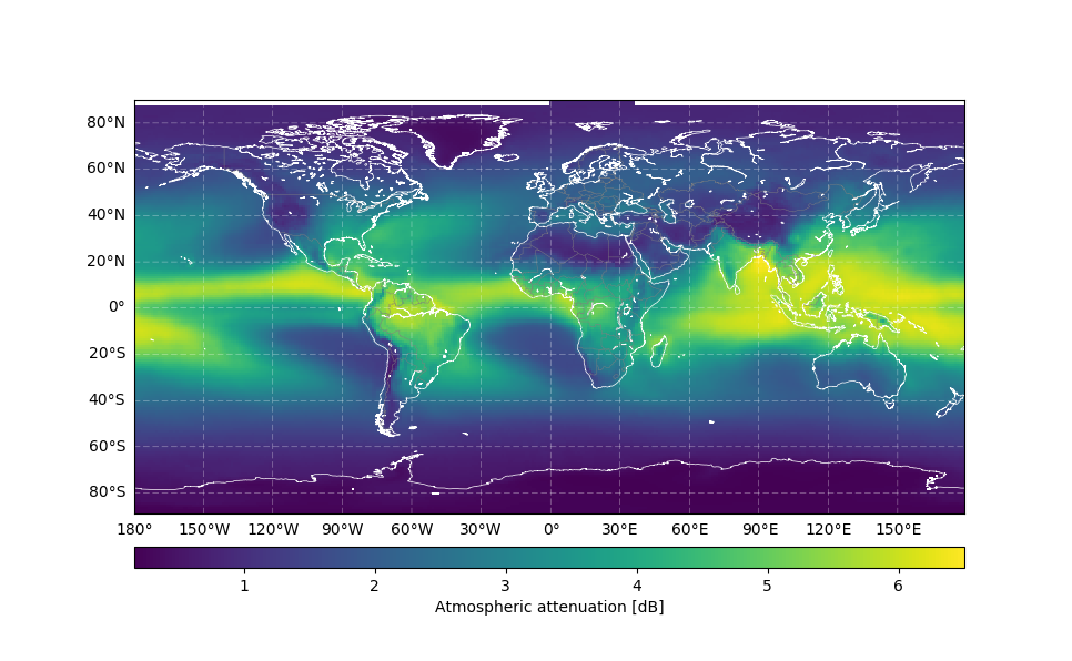
The following code example shows the usage of ITU-Rpy. More examples can be found in the examples folder.
import itur

f = 22.5 * itur.u.GHz    # Link frequency
D = 1 * itur.u.m         # Size of the receiver antenna
el = 60                  # Elevation angle constant of 60 degrees
p = 3                    # Percentage of time that attenuation values are exceeded.

# Generate a regular grid latitude and longitude points with 1 degrees resolution
lat, lon = itur.utils.regular_lat_lon_grid()

# Comute the atmospheric attenuation
Att = itur.atmospheric_attenuation_slant_path(lat, lon, f, el, p, D)
itur.plotting.plot_in_map(Att.value, lat, lon,
cbar_text='Atmospheric attenuation [dB]')ITU-Rpy has been validated using the ITU Validation examples (rev 5.1) , which provides test cases for parts of Recommendations ITU-R P.453-14, P.618-13, P.676-12, P.836-6, P.837-7, P.838-3, P.839-4, P.840-8, P.1511-2, P.1623-1.
The results of this validation exercise are available at the validation page in the documentation.
If you use ITU-Rpy in one of your research projects, please cite it as:
@misc{iturpy-2017,
      title={ITU-Rpy: A python implementation of the ITU-R P. Recommendations to compute atmospheric
	     attenuation in slant and horizontal paths.},
      author={Inigo del Portillo},
      year={2017},
      publisher={GitHub},
      howpublished={\url{https://github.com/inigodelportillo/ITU-Rpy/}}
}


